

Ever wondered how meteorologists predict hurricane paths? Let’s explore the fascinating world of the hurricane cone of uncertainty. We’ll uncover the secrets behind these vital forecasts. Stay with us as we simplify this captivating tool. The cone keeps us safe and informed during storm season.
The hurricane cone of uncertainty helps predict storm trajectories. Key aspects to remember include:
- It represents the probable path of the storm center.
- Width increases with time, indicating greater uncertainty.
- Impacts can occur outside the cone.
- Read the cone by following its centerline.
- Be mindful of potential risks and impacts in areas beyond the cone.
We’ll delve into the hurricane cone of uncertainty in this article. Learn its creation, limits, and what affects its accuracy. We’ll help you interpret it for improved safety and readiness.
What is a hurricane?
Warm seas near the equator create hurricanes. These storms are like spinning tops with powerful winds and torrential rain. Warm water fuels them, growing stronger as they move.
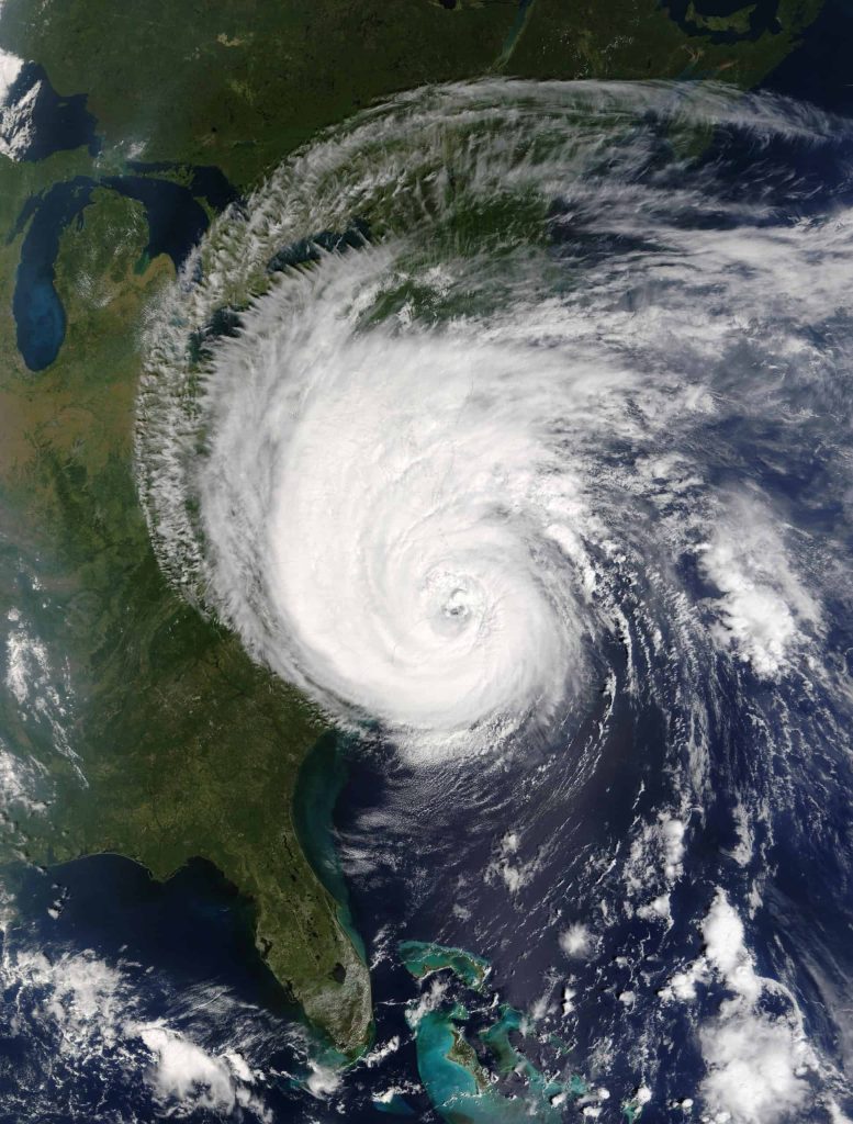
With winds between 74–157 miles per hour (mph) or higher, these events can be destructive. They can lead to devastation, flooding, and even fatalities. For those in coastal regions, predicting hurricane behavior is a must.
Importance of Accurate Hurricane Forecasting
Reliable hurricane forecasts can help people like you brace for impact. Weather experts, called meteorologists, use special tools. They have ways to estimate hurricane direction and landfall intensity.
Forecasts enable governments and people to act with caution. The “hurricane cone of uncertainty” is a key tool for weather experts.
Another essential tool is the hurricane naming system. This promotes easier tracking and awareness of storms. Especially if there are multiple hurricanes. It also increases the likelihood that more people will pay attention to the cone of uncertainty.
Understanding the Hurricane Cone of Uncertainty
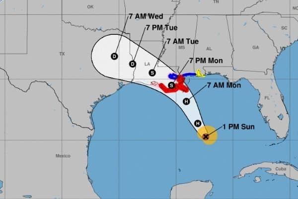
The hurricane cone of uncertainty has various names. It’s also dubbed “the cone of error” or “the cone”.
This is a graphic that shows different hurricane tracks. Over a five-day period, any of these paths can shift. It’s designed to provide a general idea of where the storm might head.

The cone helps people understand forecast changes. Weather factors can change rapidly and affect a hurricane’s track. The size and shape can vary as the hurricane approaches land. This depends on how confident the forecasters are in their predictions. The cone is wide at first, but as the hurricane gets closer, the cone narrows.
Strong winds and heavy rain may affect you even when you’re outside the cone.
How it’s Created
Complex computer models, satellites, and stations form the cone. These process vast amounts of data like wind speed, air pressure, and temperature. Meteorologists use this data to create a series of storm “models”. These models are hurricane path predictions.
Weather experts combine all the models, which creates the cone. This cone shows the most likely paths that the hurricane might take. The cone updates with new data and insights as the storm progresses.
Limitations and Misconceptions
The cone is a great tool, but keep in mind that it’s not flawless, and it has limits. The cone shows the possible course of the eye of the storm (center of the storm). Although, it doesn’t cover impacts like the extent of wind, rain, or storm surge.
The cone represents the average error of past forecasts. That means there’s at least a 30% chance the predicted course will change. As well, changes in storm direction or speed may lead to paths outside the cone. That’s why you should be watchful and prepared, regardless of if you’re in the cone.
Factors Affecting the Cone of Uncertainty
Let’s explore what contributes to the hurricane cone’s uncertainty. Changes in weather conditions can affect them. Also, the prediction models aren’t perfect. The effects of climate change also play a part.
Learning about these factors helps us. It shows us why predicting hurricanes is hard. We can also see why we must stay alert during storm season.
Meteorological Variables
Many things can affect the cone’s accuracy. These include wind patterns and sea temperatures. Atmospheric conditions also play a role. These factors can change quickly. This makes it hard to predict a storm’s exact path.
Model Errors and Uncertainties
Hurricane prediction models have improved over time, but they’re not perfect. Incomplete or inaccurate data can influence model accuracy. As well, earth’s atmospheric complexities can further complicate matters.
Any of these elements can lead to errors in the cone. This is why it’s essential to stay informed and heed official warnings.
The Role of Climate Change
The change in climate can affect hurricane behavior. This can alter their frequency, intensity, and paths. Forecasting models must adapt as global temperatures increase. These changes can make it harder to predict hurricane paths. As a result, this lessens the cone certainty.
How to Interpret the Cone
It’s vital to understand how to interpret the hurricane cone of uncertainty. The cone provides vital insights into potential storm paths and related risks. As well, it’s important not to be overly confident with forecasts.
Reading and Understanding the Cone
It’s important to remember that the cone shows multiple potential paths. It doesn’t indicate a single, definitive course. As you move further out in time, the cone will widen. This indicates a greater degree of uncertainty.
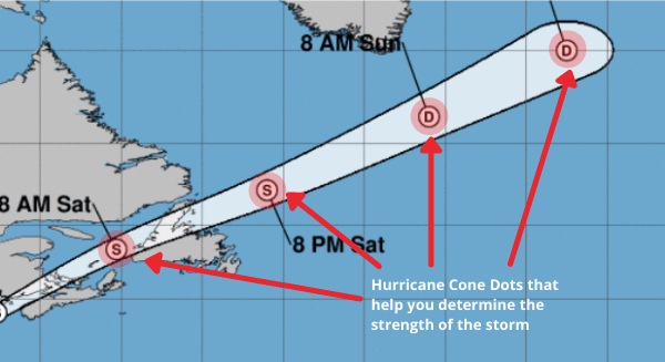
Letter Code | Storm Type | Wind Speed |
D | Tropical Depression | <39 MPH |
S | Tropical Storm | 39–73 MPH |
H | Hurricane | 74–110 MPH |
M | Major Hurricane | >110 MPH |
Probability of Impact
It’s important to remember that the cone doesn’t pinpoint an exact area. Probability maps help predict hurricane impact odds in a specific location. The hurricane cone’s accuracy depends on its width or diameter. It indicates how far the storm’s center can travel. As the hours pass, the data becomes more accurate.
With this, the National Hurricane Center (NHC) can better predict storm centers. This fine-tunes travel projections. The NHC will update the hurricane cone for the Atlantic Basin every 6 hours. It’s scheduled for Eastern Time (ET) at 5 a.m., 11 a.m., 5 p.m., and 11 p.m.
Avoiding Overconfidence in Forecasts
The cone’s forecast is not a guarantee—don’t be overly confident. Follow updates from forecasters and emergency management officials. Follow their guidance for staying safe during a hurricane.
Improvements in Hurricane Forecasting Technology
Advancements in state-of-the-art storm tracking make a difference. They boost our ability to predict and brace for these hurricanes.

Let’s explore the advanced developments in weather models and remote sensing. These have improved the accuracy of the hurricane cone of uncertainty.
How Scientists Work to Improve Hurricane Models
Scientists study past storms, run experiments, and refine model accuracy. With more knowledge, hurricane prediction improves, which can save lives.
The Role of Technology and Forecasting
Meteorologists strive to improve their predictions.
Technology contributes to that, like:
- New satellites.
- Better computers.
- More precise sensors.
- Advanced weather stations.
This technology helps scientists collect even more data. Forecasters use this data to enhance hurricane path and strength projections. These improvements guarantee better forecasts in the future.
The NHC says the center of the storm stays inside the cone for about 60–70% of forecasts.
Advances in Weather Models
Forecast models have improved a lot over the years. In part, this is thanks to improved problem-solving methods and computer power. This creates a more accurate forecast, which reduces the cone size. This results in better tracking precision.
Remote Sensing and Satellite Data
Experts can quickly refine predictions and alter potential storm paths. This is because of near real-time details on multiple factors. This includes the storm location and how strong it’ll be.
Artificial Intelligence in Hurricane Prediction
Machine learning, also known as artificial intelligence (AI), plays a role in hurricane forecasting. AI analyzes vast amounts of historical and current data. This helps weather experts find patterns and changes that they might not notice. This can result in better and quicker forecasts. This ultimately makes the cone more precise.
Hurricane Cone of Uncertainty Facts
The NHC says that the cone shows the likely track of the storm’s center. The broader the cone, the more the storm’s center can move. This means the information is less certain. As the forecast becomes more certain, the cone becomes more narrow. The NHC says the center of the storm stays inside the cone for about 60–70% of forecasts.

The eye wall produces the most violent winds and heaviest rain
They warn that the risks from a storm may reach beyond the cone.
Some risks include:
- Strong winds
- Storm surges
- Dangerous flooding
- Tornadoes
In addition, the cone shouldn’t be used to decide if you should prepare. Instead, you should heed local emergency and preparedness agency warnings and information.
In this table, we’ll show ten facts about the hurricane cone of uncertainty. This will give you insights into how it’s made, what it’s for, and why it’s important. Knowing all this helps you see why the cone is key for predicting hurricane tracks. It helps people prepare for possible storm impacts and can save lives.
Facts about Hurricane cone of Uncertainty |
Facts about Hurricane cone of Uncertainty |
It’s based on historical forecast errors |
The cone’s width increases with time |
It is created using advanced computer models that process vast amounts of meteorological data. |
The cone only represents the potential path of the storm center |
Meteorolgical variables |
Remote sensing and satellite data have significantly improved the cone’s accuracy over time. |
Artifical intelligence is increasingly being used to enhance hurricane prediction and refine the cone. |
The National Hurricane Center (NHC) and World Meteorolgical Organization (WMO) play key roles in the development and dissemination of the cone. |
The cone should not be treated as an infallible guide but rather as a tool to understand the inherent uncertainty in hurricane forecasts. |
Understanding and interpreting the cone is essential for effective hurricane preparedness and saftey. |
The Role of Government Agencies and Meteorological Institutions
Accurate forecasting of possible hurricane paths and impacts is crucial. It ensures public safety and effective emergency responses. Government agencies and meteorology institutions collaborate. They’re involved with developing and refining the cone. They also offer vital guidance on preparation and response. We’ll look at the roles and duties of key groups.

The National Hurricane Center and the World Meteorological Organization (WMO) are two well-known groups. Working together and sharing data helps make forecasts accurate. Communities can better tackle the threats posed by these powerful storms.
The National Hurricane Center (NHC)
The NHC monitors and forecasts hurricanes in the United States. They guide people to have an effective hurricane response.
The NHC helps people prepare for and respond to hurricanes more effectively. They give updates on where the storm might go, developments, and possible impacts.
The World Meteorological Organization (WMO)
The WMO is an international organization. They work to improve the accuracy of weather forecasts worldwide. They establish standards by sharing data and coordinating research efforts.
With the help of WMO, meteorology institutions develop better prediction models.
Have you ever wondered about how hurricanes get names? The WMO is also responsible for naming all hurricanes globally. *Note—link to the hurricane name article
Collaboration and Data Sharing
Working together and sharing data among organizations is important. This teamwork results in better hurricane forecasts. This can make the cone smaller. This, in turn, can assist communities with preparing for hurricanes.
Preparing for Hurricanes in the Face of Uncertainty
In this section, we’ll talk about why being ready for storms is important. This includes advice for staying safe and making plans for evacuation. We’ll look at how people can support and aid one another. We’ll examine resources to counter the obstacles posed by hurricanes.
Importance of Preparedness
Hurricane forecasts can be uncertain. That’s why it’s vital for people and communities to be ready. They need to prepare for possible impacts. Making a hurricane plan is important. People should also stock up on necessary supplies. Keeping updated with the latest forecasts is key. This way, people can keep themselves and their property safer.
Creating a Family Emergency Plan
It’s essential to have a family emergency plan for staying safe.
Communicate with your family about:
- Preparing for an approaching storm
- Where to meet if you get separated
- Contacting each other
Include a list of important phone numbers. That should include local authorities and emergency services.
Stocking up on Essential Supplies
When a hurricane is coming, it’s important to have supplies on hand.
Assemble a supply kit with important items, such as:
- Canned and non-perishable food
- Bottled water
- Flashlights
- Batteries
- Weather radio
- First-aid kit
- Paper plates
- Plastic cups
- Paper bowls
- Plastic utensils
- Paper towels
Consider a reliable, portable generator for power backup. Not able to access a generator? Then a hand-held can opener is going to be a must to open canned goods. And, don’t forget necessities like medicine and pet supplies.
Ensure you have enough necessary supplies to last for three days.
Protecting Your Home from Hurricane Damage
Be sure to act early to secure your home from damage. Board up windows and trim nearby trees. Secure patio furniture, trashcans, and gutters to reduce damage. Use sandbags in flood-prone areas to block water and help protect your home.
Tips for Hurricane Safety and Evacuation Planning
A crucial part of readiness: a solid evacuation plan. Find safe evacuation routes and gather emergency provisions. Coordinate plans with family and neighbors. Follow the newest hurricane forecasts and local authorities’ guidance.
The Role of Evacuation Zones
Local authorities use the cone to determine evacuation zones. When leaving, heed local orders and evacuate as soon as possible. Evacuation zones are at-risk areas in hurricanes. Familiarize yourself with your zone for hurricane safety.
Local officials may advise you to evacuate. You may need to leave your home for safety.
Community-Based Initiatives and Resources
Communities can be ready for hurricanes before they even hit. Initiate local efforts, such as neighborhood watch groups and response teams. Everyone stays informed, prepared, and responsive with these measures.

The Hurricane Cone of Uncertainty: Key Takeaway
The hurricane cone of uncertainty is a useful tool for storm predictions. Stay updated with weather news and officials. Know how to read the cone, so you can be ready for a hurricane. Know when it’s time to take action. This could mean leaving the area, helping neighbors, or just getting extra supplies. Assess and review your emergency strategy plan with your household.
Keep these takeaways in mind when preparing for a storm:
- Understand the cone’s purpose: The cone shows potential paths, not an exact track. It is designed to help you grasp the shifting of hurricane forecasts.
- Stay informed: Track updates from experts, officials, and local authorities. This helps you to know about the latest forecasts and possible impacts.
- Know its limits: The cone shows the storm’s center path, not impact size. It’s based on the average error of past forecasts. This means there’s a risk the storm could diverge from the projected path.
- Hurricane forecasts change: make preparedness plans. Accumulate necessary supplies. Plan an evacuation strategy.
- Get involved in community actions: Join emergency response teams. By working together, we stay informed and prepared for possible storms.
The hurricane cone of uncertainty aids in forecast and preparation. But, it has its limitations. By being aware and recognizing those limits, you can better prepare. Be proactive against hurricanes to protect you, your family, and your home. Stay safe and watchful!
Feature image from The National Hurricane Center